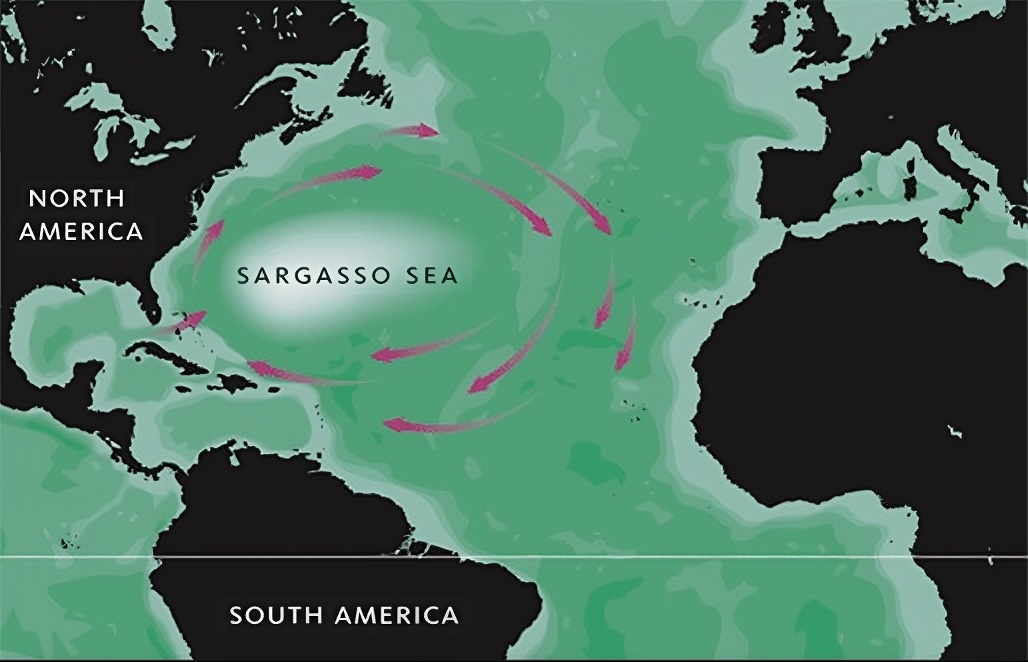
The Sargasso Sea possesses numerous characteristics. Spanning a width of 1,100 kilometres (600 nautical miles) and a length of 3,200 km (1,750 nmi), it occupies a prominent position in the North Atlantic Ocean. Its elliptical configuration is accompanied by the distinctive feature of being enveloped by ocean currents, rendering it notably static. Positioned to its west is the Gulf Stream, while the Canary Current flows to its east, the North Atlantic Current to its north, and the North Atlantic Equatorial Current to its south. Situated in close proximity to its western boundary is Bermuda Island.
Key Takeaways: Sargasso Sea
- The Sargasso Sea occupies a location within the North Atlantic Ocean, approximately bordered by four prominent currents: the Gulf Stream on its western side, the North Atlantic Current to the north, the Canary Current towards the east, and the North Atlantic Equatorial Current to the south.
- Distinct from traditional seas, the Sargasso Sea lacks definitive land boundaries; its identification arises from the presence of a distinctive mass of free-floating seaweed recognized as Sargassum.
- Sargassum seaweed, an exceptional type of brown algae, conglomerates into expansive mats or rafts on the ocean’s surface. These floating rafts offer vital habitats and function as nurturing grounds for diverse marine species.
- Embedded within a clockwise oceanic circulation pattern dubbed the North Atlantic Subtropical Gyre, the Sargasso Sea operates as a pivotal component. This gyre concentrates materials, including Sargassum, at its core, accentuating the significance of this unique ecological system.
Unique Structure of the Sargasso Sea
Known as the “Sea without Shores,” the Sargasso Sea holds a vital place within a clockwise oceanic current system. This expansive marine region displays varying depths, ranging from 1,500 to 7,000 meters. Characterized by its weak currents, modest precipitation, high rates of evaporation, gentle breezes, and the presence of warm, saline waters, the Sargasso Sea possesses a unique identity. These prevailing environmental factors, combined with limited thermal mixing, contribute to its distinct ecological trait as a biologically deficient zone lacking in plankton—the primary sustenance for aquatic life, especially fish.
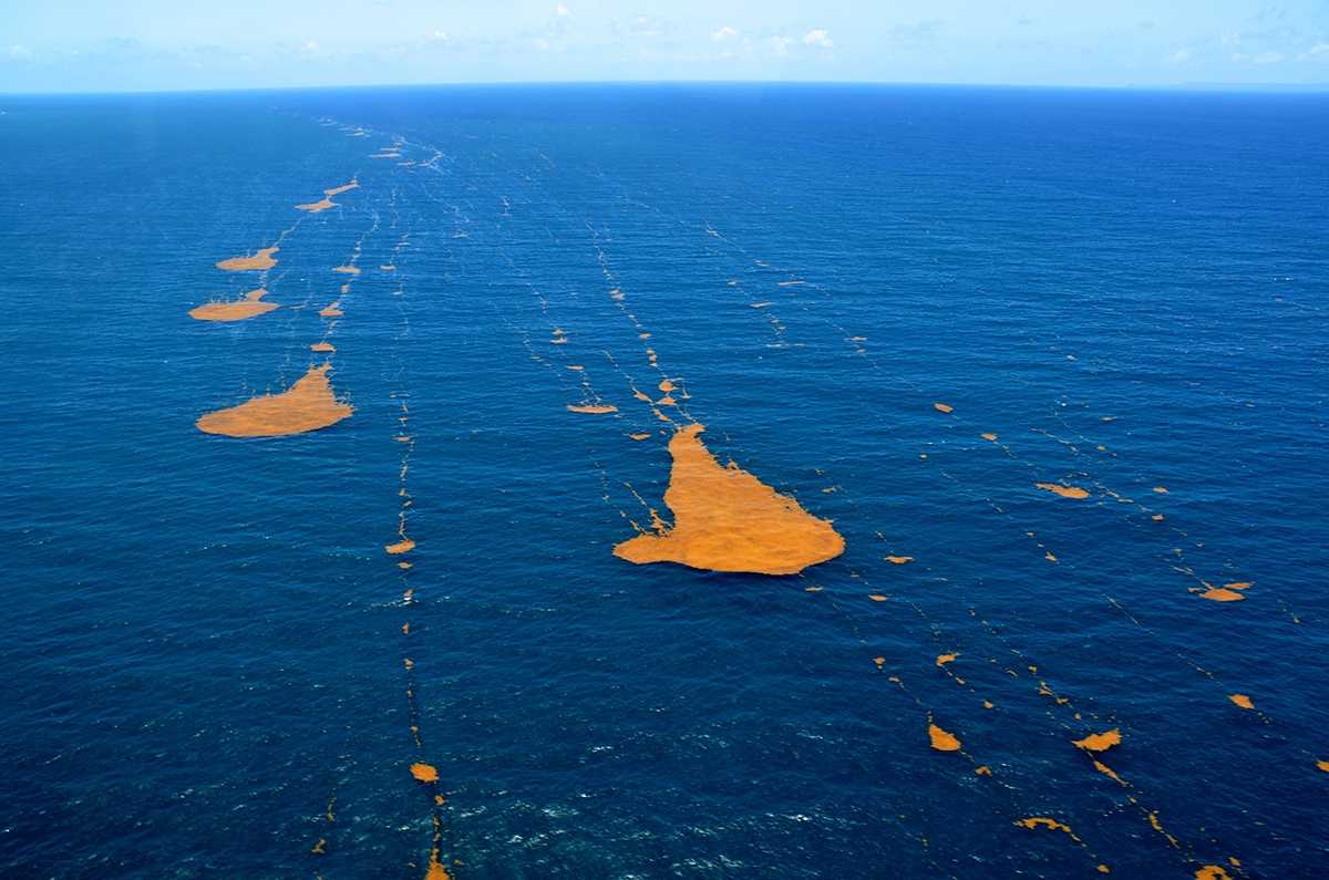
In contrast to the cold waters predominant in the North Atlantic, the Sargasso Sea stands apart with its warm temperatures, influenced by the encircling ocean currents. It benefits from consistent weather patterns and calm winds, fostering an exceptional and tranquil atmosphere. A truly exceptional feature, unmatched anywhere else on Earth, is the surface cover of brown algae. This unique vegetation comprises free-floating brown seaweeds commonly referred to as Sargassum, giving the sea its distinctive name.
Despite the apparent serenity within the surrounding currents, the Sargasso Sea is home to a subtropical gyre. This gyre displays a gentle clockwise rotation of the aforementioned brown algae present on its surface. The rotational behavior of this gyre is subject to the influence of the prevailing weather conditions in the area, further contributing to the dynamics of its ecosystem.
Brown Seaweeds of the Sargasso Sea

Brown seaweed covers the entire surface of the Sargasso Sea. These organisms are buoyant while drifting with the wind and ocean currents thanks to small bladders that resemble lobster eggs. These brown algae derive nourishment from coastal plants originating in the southeast.
Previously, there was a prevailing belief that the brown seaweeds found in the Sargasso Sea were transported to the area through coastal winds. However, subsequent research has established that these seaweeds are, in fact, indigenous to the region, flourishing hundreds of kilometers away from the coastline in this seemingly barren expanse. The Sargasso Sea is notably extraordinary in terms of its distinctive marine life because, despite other regions encompassed by similar ocean currents in the South Pacific and North Pacific, none of them harbor such dense accumulations of seaweed.
Nevertheless, due to the influence of ocean currents, numerous marine plants and even debris from nearby oceanic regions are carried into the Sargasso Sea, becoming entangled within the network of seaweed. Once entrapped in this domain, escaping becomes a formidable challenge due to the relentless surrounding currents.
Historically, navigating ships passing through this area would often encounter a state of near-motionlessness owing to exceedingly weak winds. The abundant seaweed further impeded the ships’ progress. Consequently, the Sargasso Sea earned the moniker “Horse Latitudes” as Spanish sailors, stranded in this region for prolonged periods, were compelled to discard their horses into the sea as a desperate measure to conserve drinking water in the face of water shortages.
Note: The term “Horse Latitudes” refers to subtropical regions where sailors often faced weak winds and calm seas, leading to water shortages that, according to some accounts, resulted in sailors throwing horses overboard to conserve water.
Exploration of the Sargasso Sea

In historical records dating back to the 12th century, the Arab cartographer and travel writer Muhammad al-Idrisi documented the tale of Ahmed ibn Umar, who was directed by the Moorish ruler Ali ibn Yusuf to embark on a westward voyage towards a sea enveloped in marine grass.
Similarly, a poem authored by the Roman writer Rufus Festus Avienus towards the end of the 4th century narrates the adventures of the Carthaginian sailor Himilco as he journeyed into distant waters beyond the Pillars of Hercules. He described encountering vast amounts of peculiar seaweed spread out like carpets.
During their exploration of the Azores Islands in the early 15th century, Portuguese sailors discovered a type of algae known as sargassum (Portuguese: sargaço), which gave the sea its name.
It was during his initial expedition to the New World in 1492 that Christopher Columbus observed significant quantities of yellowish seaweed as he traversed these waters. He christened this seaweed “sargazo.” Upon his arrival in this region, Columbus, observing the vast expanse of seaweed, mistakenly believed that he was approaching land.
Although the algae were, in reality, brown in color, their yellowish appearance arose from air bubbles that enabled them to remain buoyant on the water’s surface.
The sight of the seaweed cover was often a source of concern for sailors during that era, as they feared becoming entangled in it, although in reality, such concerns were unwarranted. Notwithstanding this anxiety, Columbus chose to instruct his crew to continue their voyage. However, once the ship became ensnared in the subtropical gyre, it could only escape the area after being held captive for three days.
The Relationship Between the Sargasso Sea and the Bermuda Triangle

The Sargasso Sea, situated at the core of the Bermuda Triangle in its western region, has become a realm of enigmatic occurrences despite being navigable by large ships and vessels without posing any real threat from the abundant seaweed.
Throughout history, from the early days of maritime exploration to the present era, the Sargasso Sea has been associated with baffling incidents involving ships vanishing and reappearing devoid of their crew members. A notable incident involving the ship named Rosalie was reported in the London Times in 1840. The vessel inexplicably disappeared and later reemerged with no trace of its crew. Strangely, the sails were set, no signs of leaks were discovered, and valuable cargo remained intact. Apart from a half-starved canary and the absence of the crew, everything appeared ordinary, leaving investigators puzzled, as no plausible explanation could be found for the fate of the people aboard Rosalie.
In 1881, the American schooner Ellen Austin encountered an unmanned ship sailing at considerable speed within this enigmatic region. The captain dispatched his crew, responsible for handling captured ships, to investigate the unidentified vessel. However, to their astonishment, the ship vanished without a trace. Two days later, when it reappeared, it was once again devoid of any occupants.
Even in modern times, the Sargasso Sea continues to be associated with various unexplained incidents. One such event occurred in 1955, when the Connemara IV was found adrift approximately 220 km away from Bermuda, yet no crew members were on board. Moreover, between the 1960s and 1980s, several unmanned boats and yachts were discovered floating aimlessly in the perplexing waters of the Sargasso Sea, contributing to the enduring mystery surrounding this intriguing marine expanse.
Conservation of the Sargasso Sea

Despite its enigmatic nature, the Sargasso Sea holds immense significance, as acknowledged by international marine scientists and oceanographers who recognize its pivotal role within the broader North Atlantic ecosystem. Oceanographers aptly liken this marine expanse to the “golden rainforest” of the ocean, signifying its ecological importance. Notably, the Bermuda Institute of Ocean Sciences has dedicated over five decades to the comprehensive study of this remarkable area.
Central to its ecological significance is the provision of sustenance for a diverse array of marine life. The brown seaweed thriving within the Sargasso Sea offers nourishment to surrounding fish, turtles, and various aquatic species. Eels undertake extensive journeys to utilize the seaweed as a favored breeding ground. When sea turtles are young, they seek refuge in the Sargasso Sea to avoid predators, but once they are older, they return to their natural habitats. Furthermore, the surface vegetation serves as a rich source of sustenance for migratory fish species, including Wahoo and Tuna, originating from distinct marine regions. Even humpback whales recognize the area as a splendid feeding ground during their migratory journeys.
However, this unique ecological sanctuary faces challenges due to the substantial influx of debris carried by ocean currents, which includes non-biodegradable plastics and various marine plant matter. In response to these threats, the Bermuda Government has taken proactive measures to safeguard the Sargasso Sea. The initiation of protective efforts underscores the significance of preserving this ecologically vital region for the benefit of the marine ecosystem and the broader global environment.