In the midst of tumultuous events like thunderstorms, lightning strikes, hurricanes, or sudden flash floods, there are several intriguing natural phenomena that often escape our attention. Every so often, just prior to the brewing of a storm, arcus clouds swiftly manifest. The arcus cloud stands as one of the more exceptional atmospheric phenomena, and it is further classified into two distinct types: the “shelf cloud” and the “roll cloud” (or tube cloud).
Key Takeaways: Arcus Cloud
- Arcus clouds typically form along the leading edge of a thunderstorm’s downdraft, also known as an outflow boundary. They can also develop in non-thunderstorm situations, such as cold fronts or strong wind events.
- Arcus clouds have a distinct flat base, often appearing darker and more menacing than the surrounding sky. Their upper part may exhibit turbulence and often resembles a shelf extending from the main cloud.
- The presence of an arcus cloud, particularly a shelf cloud, can signal the approach of severe weather, including strong winds, heavy rain, and thunderstorms.
- Arcus clouds can be observed in various regions around the world, but they are more commonly associated with regions prone to severe weather, such as the central United States.
Arcus Cloud and Types
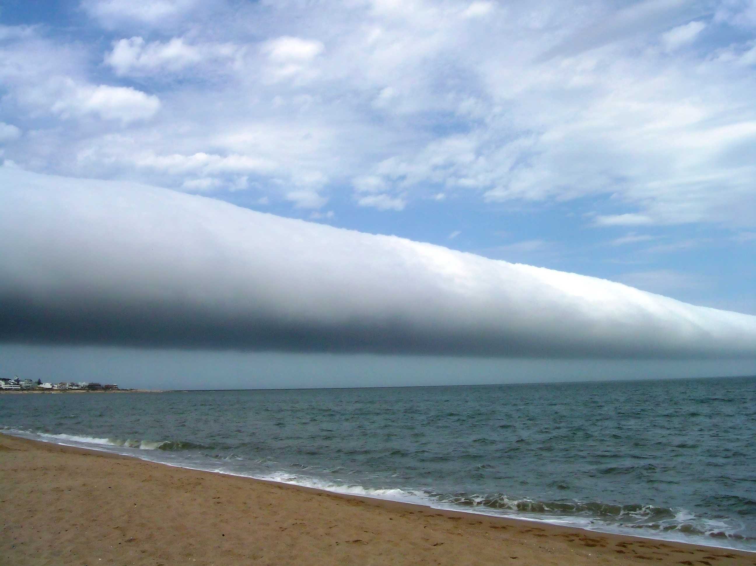
Captured on the shores of Las Olas in southern Uruguay in January 2009, this astonishing image showcases how low clouds can descend. The image also unveils another peculiarity: Some clouds can appear to roll like a tube across the sky even in the absence of apparent storm signals.
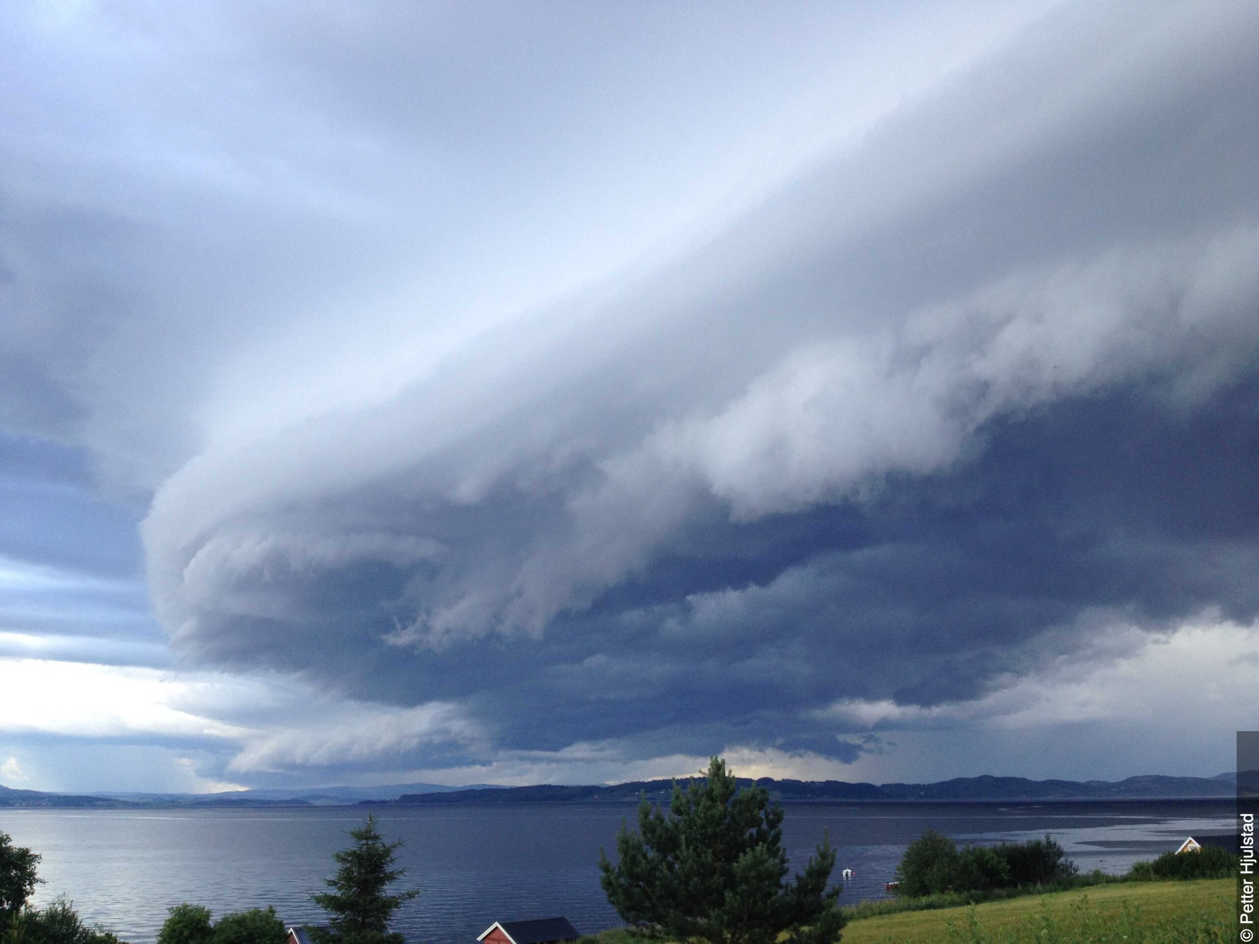
These tube-like clouds are referred to as “arcus clouds.” An arcus cloud forms when upward and downward air currents twist the leading edge of a storm system sideways into a cylinder. Arcus clouds come in two types: The cylindrical ones, known as “roll clouds,” form independently of storms, while the second type, known as “shelf clouds,” emerges detached from the front of a storm, similar to a car’s detached front bumper.
The formation of these clouds is a remarkable interplay of atmospheric dynamics, often delivering visually striking and awe-inspiring sights in the ever-changing tapestry of our skies.
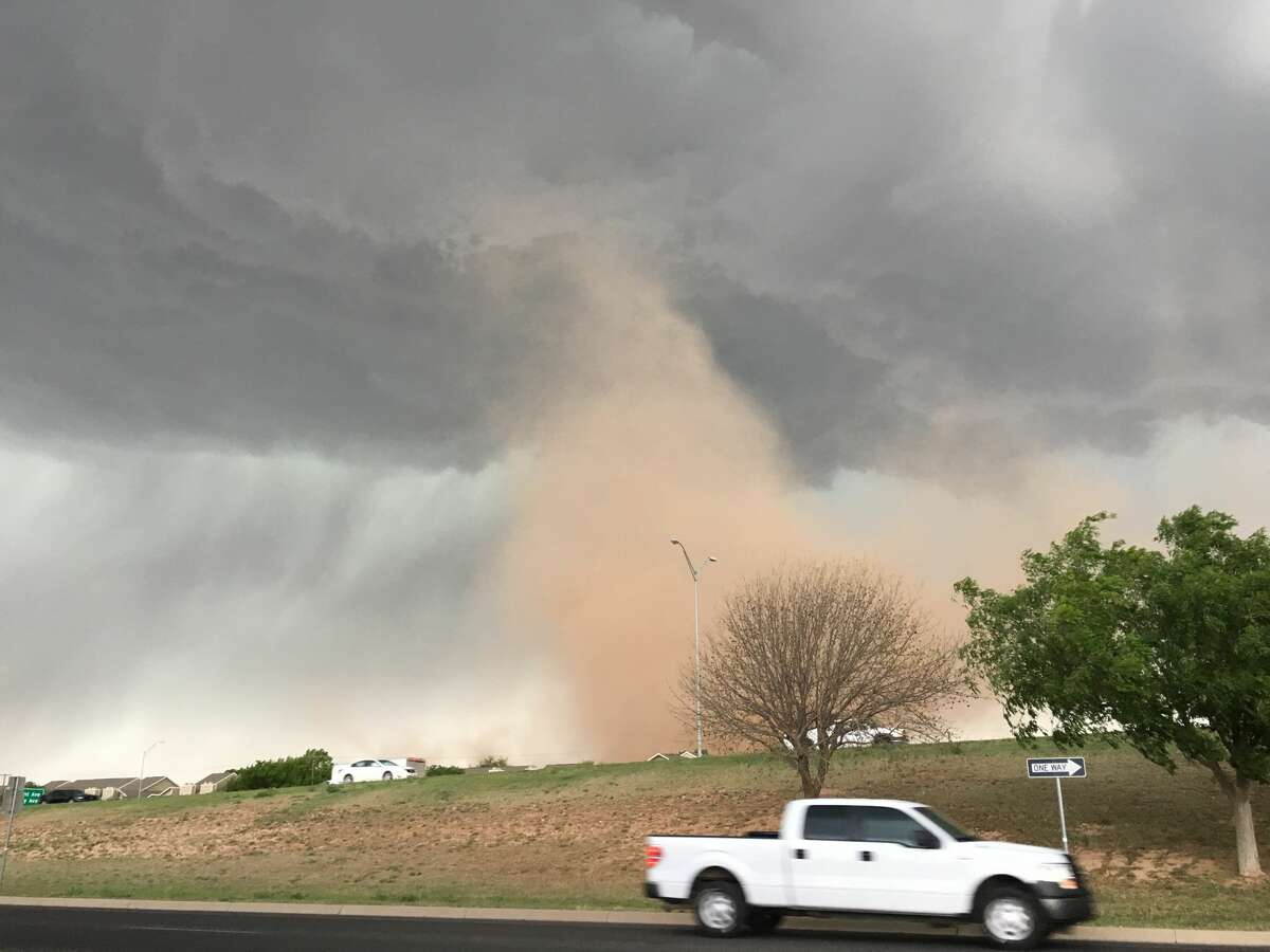
Roll or tube clouds are often mistaken for tornadoes because they can appear quite low in the sky. Despite their superficial similarities, they have no common traits with tornadoes.
Firstly, roll clouds are generally harmless. While the vertical vortex of a tornado can cause damage at ground level, potentially devastating entire cities in extreme cases, roll clouds move slowly and horizontally. Moreover, unlike tornadoes, they form ahead of a storm, not behind it. Lastly, they lack a physical connection to the originating storm.
It’s important to differentiate between these atmospheric phenomena to avoid confusion and better understand the distinctive behaviors and characteristics of various cloud formations and weather patterns.
How Is a Roll Cloud Formed?
Roll or tube clouds can emerge in nearly any geographical area, yet they remain an infrequent phenomenon. They are most frequently spotted in the Carpentaria Gulf of Australia, to the extent that this region is the sole location where their formation can be reliably anticipated. Their conspicuous differentiation from other cloud formations distinguishes them, setting roll clouds apart from shelf clouds.
This specific type of arcus cloud holds the name “kangólgi” among the Aboriginal community and is recognized as the “morning glory” by the local English inhabitants. Notably, these clouds tend to manifest predominantly during the months of September to November, particularly in the early hours of the day. A distinguishing characteristic is that their origins remain elusive until the associated storm begins to take shape.
Enthusiastic glider pilots, drawn by the allure of these splendid cloud formations, frequently congregate in the Gulf region. It is during October that these clouds are most frequently observed, often making their appearance up to four times during this period.
Warm air accumulates on top of cold air, causing roll clouds to form as a result of the wind’s rapidly shifting motion. This rolling motion creates the distinctive cylindrical shape of the cloud.
Roll clouds exhibit a distinctive horizontal movement resembling rolling motions. These formations, originating from a single continuous mass of cloud and maintaining their shape and velocity during movement, are termed soliton waves, or “solitons.” Positioned as low as 2 kilometers above ground level, the base of arcus clouds can be relatively close to the Earth’s surface.
Due to their separation from larger cloud bodies, roll clouds are categorized as “accessory clouds.” Primarily, cumulonimbus clouds serve as the common source for arcus clouds, although instances of formation from cumulus clouds can also occur.
Certain arcus clouds can attain significant dimensions, showcasing an impressive expanse that extends as far as 480 kilometers above the ground, as vividly captured in the provided photograph. The photo was taken during the STS-51-J mission on October 5th of the same year.
How Is a Shelf Cloud Formed
A shelf cloud is a low, horizontal, wedge-shaped arcus cloud. They typically form at the base of cumulonimbus clouds, which often bring storms. However, they can form over various types of convective clouds. The rising cloud motion is usually visible along the outer edge of the shelf cloud, while the underside appears turbulent and fragmented due to the influence of winds.
Cold air from the downdraft of a storm cloud collects at the surface and forms a leading edge called the gust front. The storm’s updraft’s warm air breaks it up here. Different winds at the upper and lower levels (wind shear) influence the formation of a rolling cloud as the cold air underneath lifts the warm, moist air.
People who see shelf clouds may think they are seeing wall clouds. But shelf clouds usually appear at the front end of a storm, while wall clouds form behind the storm.
An abrupt and forceful gust front, manifested as ground-level winds, induces disorder and gives rise to ascending fragmented clouds along the lower section of a shelf cloud’s leading edge. Under exceptional circumstances, curved vortices may develop, either reaching the Earth’s surface or ascending while gathering dust along their periphery. The emergence of these telltale signs within a low shelf cloud heralds the imminent arrival of an intense windstorm. A remarkable manifestation of this is an infrequent vortex termed a “gustnado,” representing the most extreme illustration.
Arcus Cloud at a Glance
How are arcus clouds related to thunderstorms?
Can arcus clouds be used for weather forecasting?
How do arcus clouds impact the atmosphere?
What is a roll cloud?
What is an arcus cloud?
References
- Dan Bush (January 17, 2006). “Astronomy Picture of the Day Archive”. NASA.
- Clarke, R. H.; Smith, R. K.; Reid, D. G. (1981). “The Morning Glory of the Gulf of Carpentaria: An Atmospheric Undular Bore”. Mon. Wea. Rev.