The intrusion of salt (or other evaporite minerals) into the layers of rock above is called diapirism. This causes a salt dome to form as a separate structural feature. These domes exhibit exclusive configurations both on the surface and below, and their identification employs methods like seismic reflection. Given their capacity to serve as reservoirs, salt domes hold significance in the realm of petroleum geology, operating effectively as traps for petroleum deposits.
Key Takeaways: Salt Dome
- Salt domes form when underground salt layers, often from ancient seas, begin to flow upward due to their buoyancy. As the salt rises, it displaces and deforms the overlying sedimentary rock layers.
- The core of a salt dome is made up of salt (sodium chloride) that has been buried and compacted over millions of years. The salt layer is often covered by layers of rock, such as shale and sandstone.
- Salt domes can create traps for hydrocarbons like oil and natural gas. Over time, these hydrocarbons can accumulate around the edges or flanks of the salt dome, making it an important target for oil and gas exploration.
- Salt domes have economic importance beyond hydrocarbons. They are often mined for salt, which has various industrial uses, including in chemical production, food preservation, and road de-icing.
Salt Dome Formation
From the Proterozoic to the Neogene era, salt basins underwent cyclic development within the stratigraphic context. The initiation of a salt dome’s formation commences with the salt being deposited in a confined basin. Within these basins, the outflow of water surpasses the inflow. More precisely, the basin experiences a net water loss through evaporation, which leads to the salt precipitating and depositing. Even though the rate of salt sedimentation is much faster than that of clastic sediments, it is known that a single episode of evaporation rarely produces the large amounts of salt needed to make a layer thick enough for a salt diapir to form. This implies that a prolonged phase of intermittent basin flooding and evaporation must transpire.
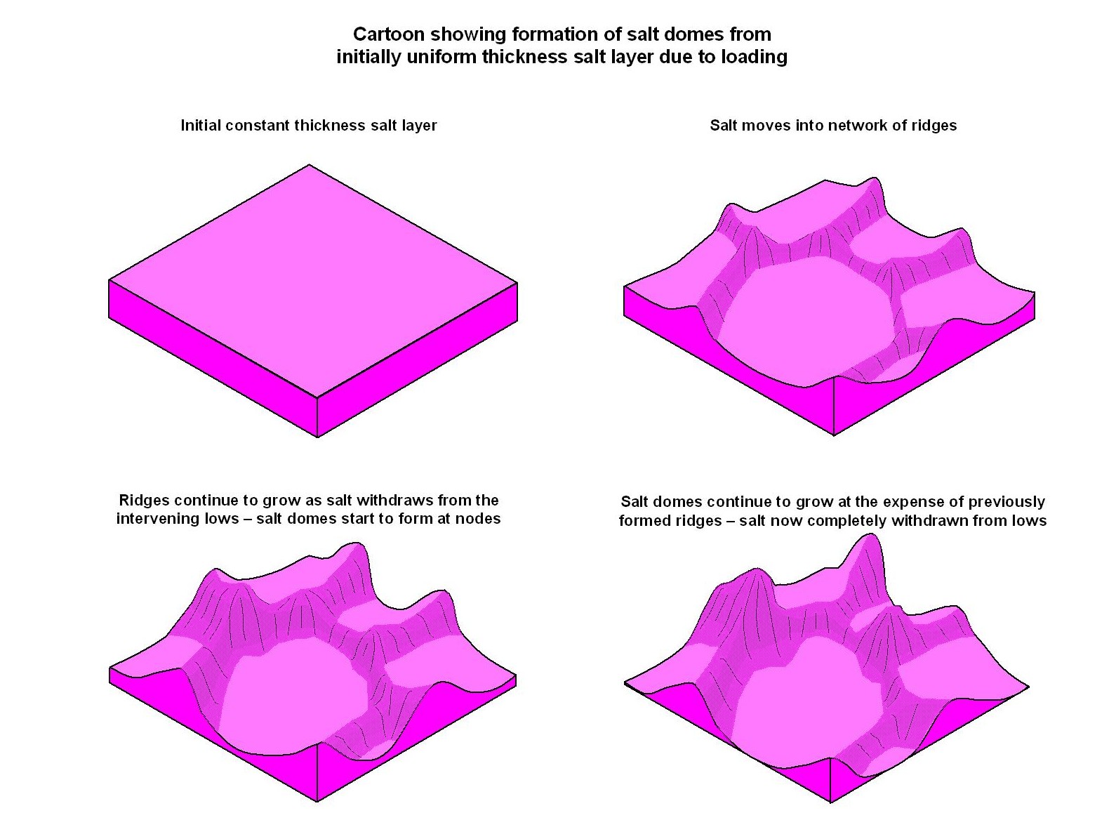
Over the course of time, sediment accumulates and buries the salt layer, becoming progressively concealed beneath a growing load of overlying material. In the past, scientists thought that the salt diapir was formed when the sediment above it became compacted and lost some of its buoyancy. This caused the salt to rise and push into the strata above it, creating a salt diapir. However, after the 1980s, the dominant driving force behind salt flow was attributed to differential loading.
Differential loading can arise from gravitational influences (gravitational loading), the induced alteration of salt boundaries (displacement loading), or thermal variances (thermal loading). The salt’s movement surmounts the resistance of the overlying load as well as boundary friction, facilitated by overlying extension, erosion, thrust faults, ductile thinning, or other regional deformations. The vertical expansion of salt formations exerts pressure on the upper surface, inducing extension and faulting. Upon complete penetration of the overlying strata, the salt can ascend through a process termed passive diapirism, wherein sediment accumulation around the diapir contributes to its enlargement, eventually culminating in the creation of a dome-like structure.
Discovery Mechanisms
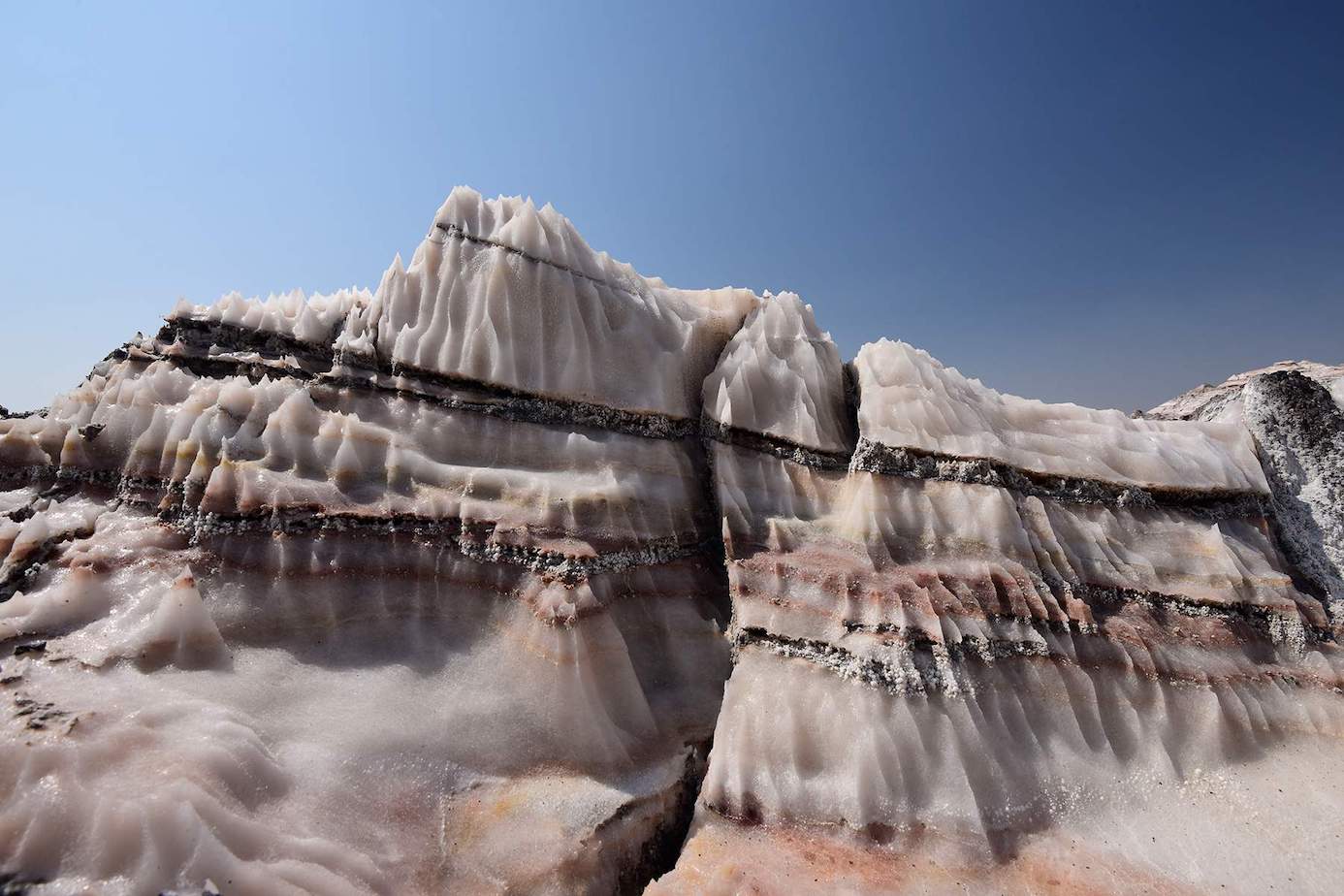
Certain salt domes become visible on the Earth’s surface. Identifying them involves recognizing distinct surface formations and the surrounding phenomena. For example, salt domes might be associated with or situated close to sulfur springs and vents emitting natural gas. Some salt domes even exhibit protruding salt sheets from their summits, a phenomenon known as “salt plugs.” These plugs can merge, forming salt canopies that can later be repositioned through the sedimentation of the dome’s roof. A well-known instance of this occurs in the northern Gulf of Mexico basin. Another outcome originating from salt domes is the creation of “salt welds.” These form when dome expansion halts due to the depletion of salt, causing the upper and lower contacts to blend together.
To locate salt domes, seismic refraction and seismic reflection techniques have been employed. The latter technique, an advancement of the former, proves more efficient. Seismic refraction employs seismic waves to delineate underground geological features and structures. Conversely, seismic reflection, built upon seismic refraction methodologies, emphasizes the stark contrast in density between the salt and the surrounding sediment. Seismic approaches yield exceptional results, as salt domes often manifest as depressed sections of the crust bordered by parallel normal faults (graben), sometimes flanked by reverse faults. Progress in seismic reflection technology and the expansion of offshore petroleum exploration endeavors significantly contributed to the discovery of numerous salt domes shortly after World War II.
Commercial Uses of Salt Domes
Salt domes serve as the epicenters of numerous global hydrocarbon-rich regions. Within these salt domes, the rock salt possesses a predominantly impermeable nature. As it ascends towards the surface, it not only infiltrates but also contorts the existing rock formations in its path. This interaction with rock layers often results in an upward curvature upon encountering the dome, consequently giving rise to pockets and reservoirs that house valuable reserves of petroleum and natural gas, commonly referred to as petroleum traps. A pivotal turning point occurred in 1901 when an exploratory oil well was meticulously drilled into Spindletop Hill, situated near Beaumont, Texas. This landmark event unearthed the inaugural salt dome, shedding light on the vital role of salt in the genesis of hydrocarbon accumulations. Furthermore, it yielded a substantial oil output, thereby establishing petroleum as a financially viable energy source for the United States. Notably, numerous nations employ the technique of solution mining to create expansive subterranean caverns capable of storing significant quantities of oil or gas.
Above these salt domes, the caprock holds the potential for harboring deposits of native sulfur, which can be extracted using the Frasch process. Additionally, these caprocks can house deposits of diverse elements, including metals, sodium salts, nitrates, and other valuable substances. These resources find utility in the creation of various products, ranging from commonplace table salt to chemical de-icers.
Occurrence
Salt domes are prevalent in various regions worldwide where a sufficiently substantial layer of rock salt has developed.
Hormuz Salt Formation
In the Middle Eastern context, the upper Neoproterozoic salt found in the Hormuz Formation is linked with the widespread creation of salt domes across much of the Persian Gulf region and on the mainland in countries such as Iran, Iraq, the United Arab Emirates, and Oman. This denser salt is situated within multiple basins, including the Western Gulf, Southern Gulf, and Oman salt basins.
Paradox Basin

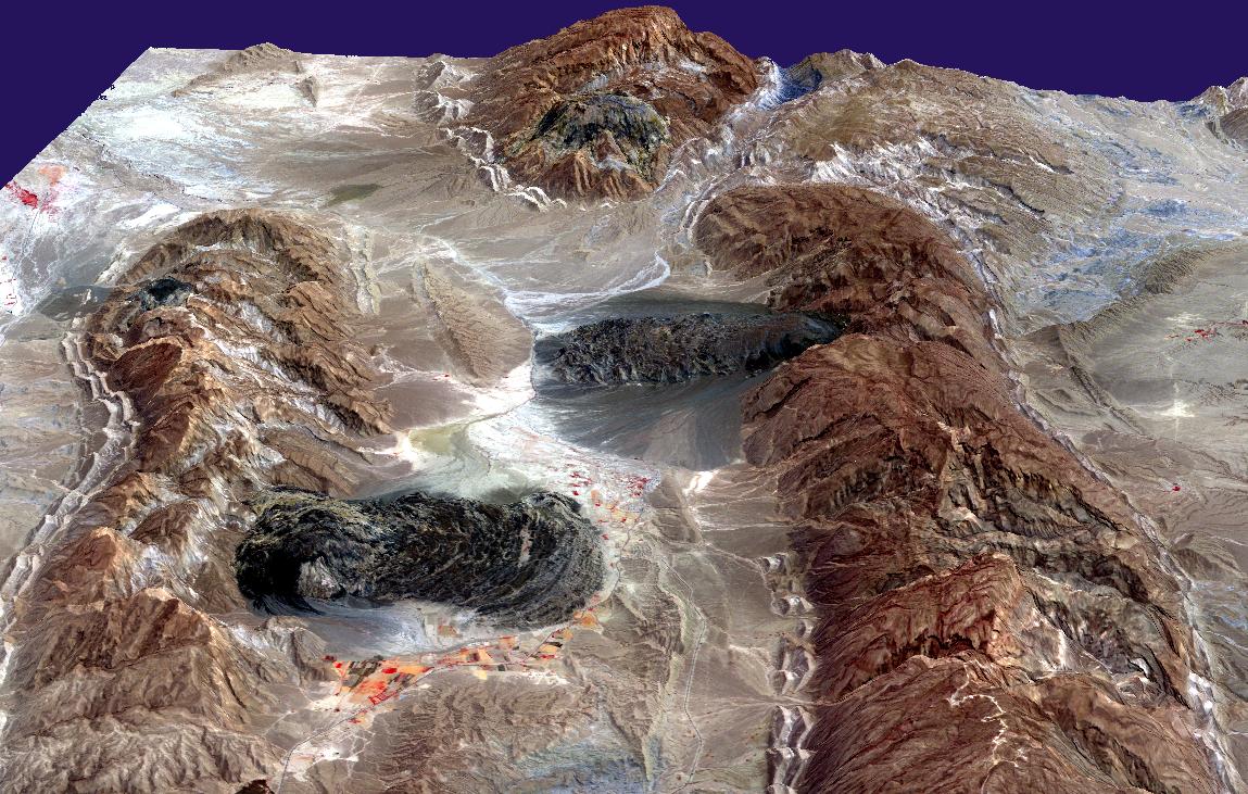
Salt domes, resulting from salt in the Pennsylvanian-age Paradox Formation, are a notable feature throughout the Paradox Basin in the United States, which stretches from eastern Utah through the southwestern part of Colorado into northwestern New Mexico.
An illustrative instance of an emerging salt dome is observable at Onion Creek, Utah, or the Fisher Towers near Moab, Utah. A salt deposit from the Paradox Formation has risen like a ridge through numerous meters of covering rock, primarily composed of sandstone. The upward movement of the salt has led to the formation of an anticline in the overlying rock (an arching upward along its central line), which subsequently fractured and eroded, revealing the underlying salt deposit.
Barents Sea
Off the northern coast of Norway, specifically in the southwestern portion of the Barents Sea, substantial Upper Carboniferous–Lower Permian salt deposits have accumulated, giving rise to salt domes in both the Hammerfest and Nordkapp Basins.
Zechstein Basin
Across northwest Europe, salt domes have been formed by the Upper Permian salt from the Zechstein Group, extending over the Central and Southern North Sea and further eastward into Germany.
Morocco–Nova Scotia Connection
In the Essaouira Basin, situated both onshore and offshore in Morocco, salt domes have been fashioned from Upper Triassic salt deposits. A comparable salt sequence, known as the Argo Formation, has led to the creation of salt domes along the corresponding Nova Scotia margin.
Gulf of Mexico
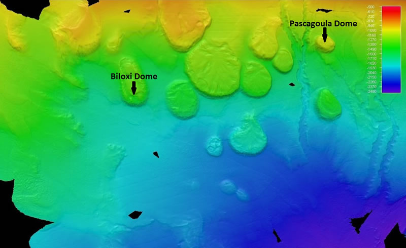
The Gulf Coast is host to an excess of 500 currently identified salt domes, originating from the Middle Jurassic Louann Salt. Notably, this region is home to the majority of the US Strategic Petroleum Reserve. This area also includes Avery Island, a salt dome-formed islet in Louisiana.
South Atlantic Salt Basins
During the separation of the South Atlantic landmasses, salt from the Aptian stage of the Lower Cretaceous era was deposited within the regions of thinned crust along both the Brazilian and corresponding Angola/Gabon margins, ultimately resulting in the development of numerous salt domes.
Messinian Salt Formation
Amidst the Messinian salinity crisis during the Late Miocene epoch, substantial layers of salt emerged as the Mediterranean Sea underwent desiccation. Following the re-flooding of the sea, subsequent sedimentation triggered the formation of salt domes.
FAQs Salt Dome
Can you visit salt domes as a tourist?
Are salt domes stable or prone to collapse?
How do salt domes impact our daily lives?
Are salt domes prone to geological hazards?
References
- Hudec, Michael R.; Jackson, Martin P. A. (2007). “Terra infirma: Understanding salt tectonics”. Earth-Science Reviews.
- Schultz-Ela, D.D; Jackson, M.P.A; Vendeville, B.C. (January 12, 1992). “Mechanics of Active Salt Diapirism”. Tectonophysics.
- McCalla C. (2008). “Geosights: The Onion Creek salt diapir, Grand County”. Survey Notes.