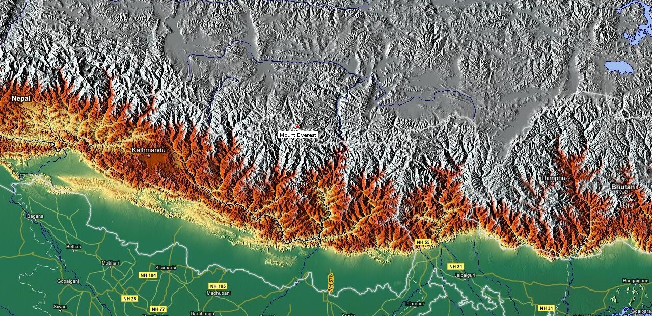
Mount Everest, situated atop the majestic Himalayas in South Asia, straddles the boundary between Nepal and China’s Tibet Autonomous Region, precisely at coordinates 27°59′ N and 86°56′ E.Boasting an impressive elevation of 8,848.86 m (29,031 ft 8+1⁄2 in), Everest stands unrivaled as the highest peak on Earth. Revered by local communities, this imposing mountain, akin to other lofty summits in the vicinity, holds sacred significance. Embracing its Tibetan designation, Chomolungma, it symbolizes the “Goddess Mother of the World” or “Goddess of the Valley.” In Sanskrit, it is bestowed with the name Sagarmatha, signifying the “Forehead of the Sky” or “Peak of Heaven.”
Prior to the year 1852, the distinction of Everest as the world’s loftiest mountain remained unknown. It was the Indian mathematician Radhanath Sikdar who made the initial discovery of the mountain and subsequently determined its height, unveiling this information to the public. Initially dubbed “Peak XV,” the mountain was later bestowed with its present name in 1865 in honor of Sir George Everest, who served as the Surveyor General of India from 1830 to 1843.
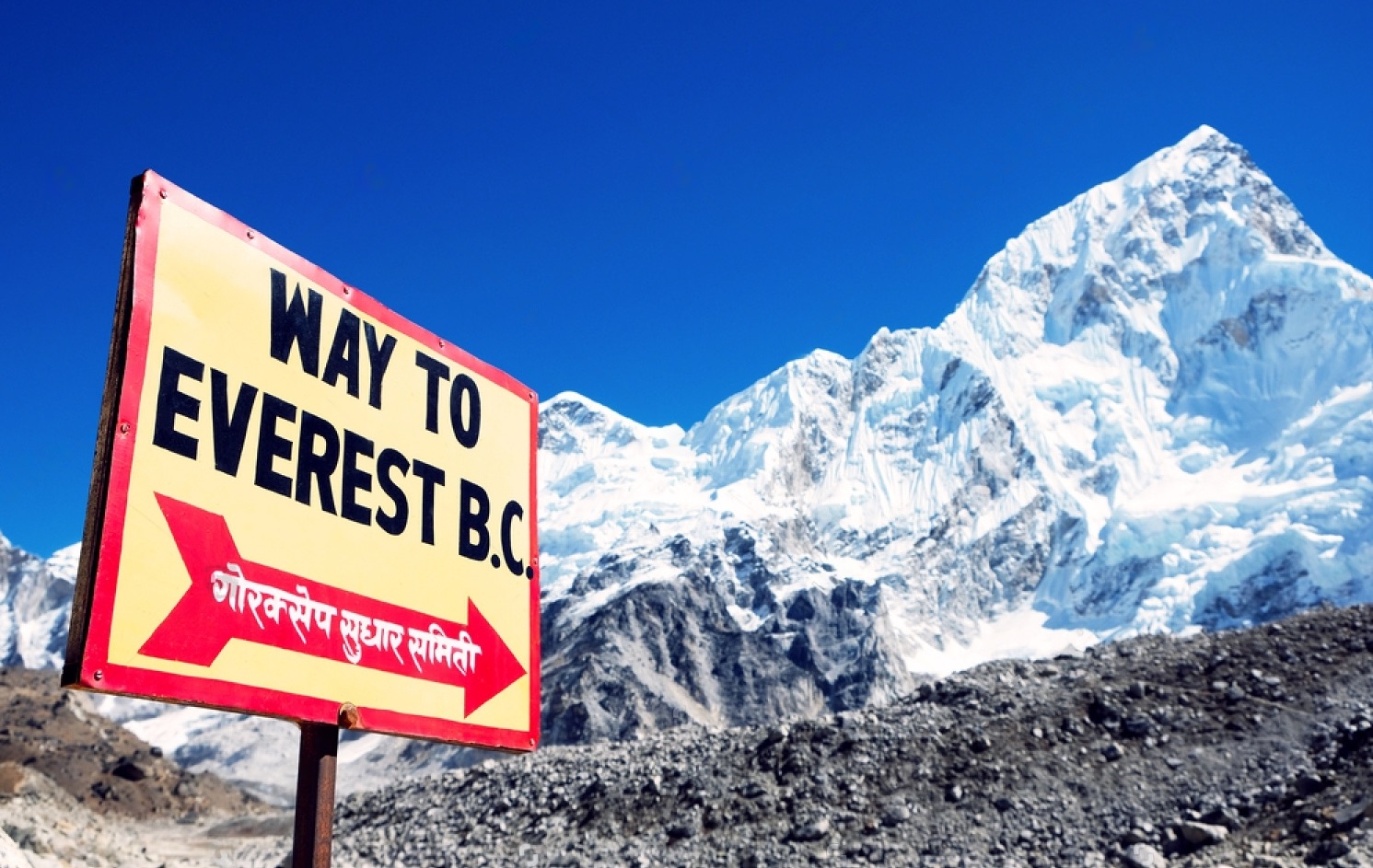
Throughout history, over 5,000 intrepid individuals have undertaken the formidable ascent of Mount Everest. Regrettably, more than 300 lives have been lost in pursuit of this ambitious feat. The endeavor necessitates obtaining a permit, obtainable from either the Nepalese or Tibetan governments, at a cost typically ranging from $25,000 to $40,000, which includes the essential $11,000 fee required to reach the summit. The entire expedition, encompassing the journey to the base camp and the actual ascent, spans approximately three months, with the climb itself lasting approximately 40 days.
Key Takeaways: Mount Everest
- Mount Everest’s summit reaches an elevation of approximately 8,848.86 meters (29,031.7 feet) above sea level, making it the highest point on Earth.
- It is located on the border between Nepal and China (Tibet), in the Himalayas mountain range.
- The first successful ascent to the summit was made on May 29, 1953, by Sir Edmund Hillary of New Zealand and Tenzing Norgay, a Sherpa of Nepal, as part of the British expedition led by Sir John Hunt.
- The Sherpa people of the region are renowned for their expertise in mountaineering and play a crucial role in supporting climbers during expeditions.
Formation and Physical Features
The formation of the Himalayan mountains can be attributed to the movement of the Indo-Australian Plate from south to north and its collision with the Eurasian Plate approximately 40 to 50 million years ago. This tectonic interaction set in motion the processes that eventually gave rise to the majestic Himalayas. Over the course of millions of years, around 25 to 30 million years ago, the mountains began to emerge, and during the Pleistocene Epoch (approximately 2.6 million to 11,700 years ago), they assumed their current distinct form. The Himalayan range, stretching for about 2,400 kilometers, found its focal point in Mount Everest and the surrounding peaks, as they were shaped by these dynamic tectonic forces.
Modern data from global positioning systems has revealed that Everest continues to experience movement, shifting northeastward at a rate of a few centimeters each year, along with minor vertical uplift since the late 1990s.
Mount Everest itself is a geological marvel, composed of multiple layers of folded rocks. Its lower levels comprise igneous granite, metamorphic schist, and gneiss, while sedimentary rocks of marine origin are found at higher elevations. These sedimentary remnants are vestiges of the former floor of the Tethys Sea, which ceased to exist following the collision of the Indo-Australian and Eurasian Plates. Notably, the limestone formation known as the Yellow Band is visibly present just below the summit.
The surroundings of Mount Everest boast an impressive array of other high mountains. Changtse peak, which is located to the north, rises to a height of 7,560 meters (24,803 feet), and Khumbutse (6,665 meters – 21,867 feet), Nuptse (7,861 meters – 25,791 feet), and Lhotse (8,516 meters – 27,940 feet) encircle Everest on the western and southern sides.
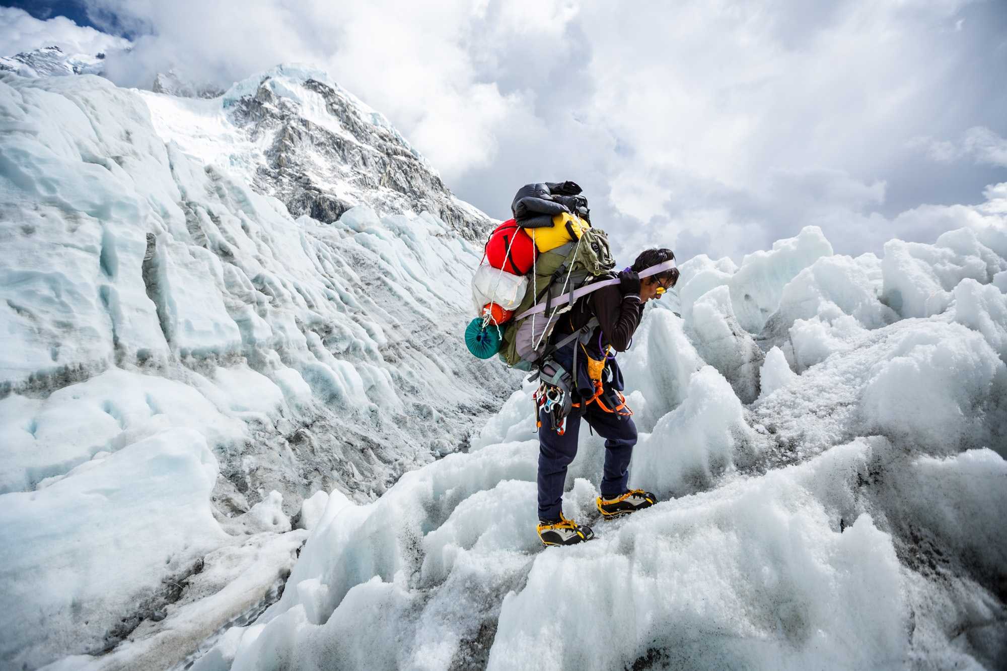
With a distinctive three-sided pyramid shape, Everest presents prominent ridges where the three flat planes on its sides converge. The North Face of Everest faces Tibet, while the Southwest Face overlooks Nepal. The Nepalese side features the formidable Khumbu Icefall, a significant challenge for climbers. However, the East Face (Kangshung) also rises majestically from the Tibetan side.
A thicker, softer layer that ranges in thickness from 1.5 to 6 meters (5–20 feet) sits on top of a firm layer of ice that resembles rock at the Everest summit. The snow level reaches its zenith in September, following the monsoon season, and descends to its lowest point in May, when it contends with powerful northwesterly winter winds. The summit and upper slopes of Everest are situated at such high altitudes in the Earth’s atmosphere that the oxygen level at the peak is only about one-third of that at sea level. This harsh environment of oxygen deprivation, fierce winds, and extremely low temperatures renders the summit inhospitable for any plant or animal life.
Climate
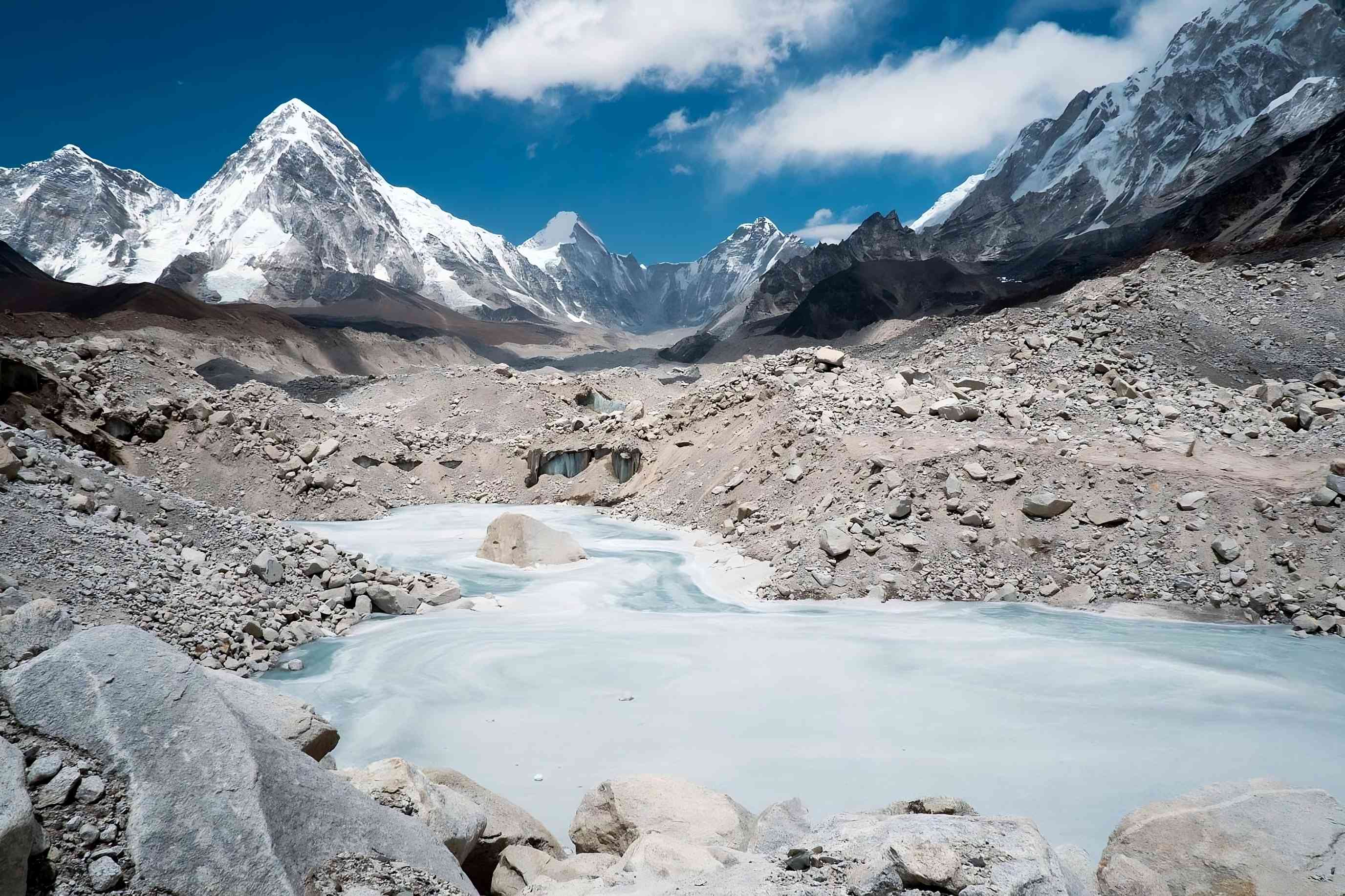
From its peak to its base, glaciers completely encircle Mount Everest. These glaciers, along with the icefields and ice valleys they accompany, have distinct names and collectively play a significant role in the severe erosion that not only Everest but also other lofty Himalayan peaks are experiencing.
Among these glaciers, the Khumbu Glacier of Everest stands out, encompassing multiple distinguishable branches that feed into the Lobujya River in Nepal. On the Tibetan side, the Rongbuk and Pumori glaciers feed the Rong River, while the Kangshung Glacier feeds the Kama River. Ultimately, these rivers converge into the Arun River, making their way from the Himalayas into Nepal. The valleys formed by the Rong, Dudh Kosi, and Kama rivers provide the main northern, southern, and eastern access routes for climbers aiming to reach the summit of Mount Everest.
Mount Everest’s climate is characterized by its extreme harshness, rendering it incapable of supporting any form of life. At the summit, the highest average daytime temperature, occurring in July, hovers around −2 °F (−19 °C) . During the coldest month of January, temperatures can plunge to a chilling range between −33 °F (−36 °C) and −76 °F (−60 °C). The mountain is notorious for sudden storms and unpredictable temperature drops. Notably, Everest’s summit’s immense altitude places it near the lower boundary of the jet stream, causing winds of up to 100 miles (160 km) to be common. Precipitation manifests primarily in the form of snow during the summer monsoon season, which extends from late May to mid-September. Climbers daring to conquer Everest face a high risk of frostbite due to the extreme cold temperatures prevailing on the mountain.
The Height of Everest
The precise height of Mount Everest has been a subject of considerable debate, stemming from various factors such as changing snow levels, gravitational anomalies, and light refraction. The widely used value of 29,028 feet (8,848 metres) came from measurements made by India between 1952 and 1954. Up until 1999, most researchers, mapping companies, and publishers used this value as the standard.
However, more recent efforts have been made to reevaluate Everest’s height. In 1975, a Chinese survey reaffirmed the figure of 29,029.24 feet (8,848.11 metres), providing additional support to the previously established measurement. In 1987, Italian researchers utilized satellite measurement techniques, arriving at a value of 29,108 feet (8,872 metres). However, the scientific community did not generally accept this result.
In 1992, another Italian study focused on employing the Global Positioning System (GPS) and laser measurement technology. After accounting for the 2-meter ice and snow cap at the summit, their findings indicated a height of 29,023 feet (8,846 metres). However, their methodology was considered flawed, and this result was not adopted as the official measurement.
It was only in 1999, with the support of the National Geographic Society (USA), that a new measurement study aligned with the 1954 figure of 29,035 feet (8,850 metres), restoring it as the accepted height of Mount Everest.
While Mount Everest holds the distinction of being the highest mountain on Earth when measured from sea level, it’s worth noting that Hawaii’s Mauna Kea holds the title of the world’s tallest mountain when considering the entire mountain’s height, starting from its base deep in the Pacific Ocean. Mauna Kea’s above-water portion measures 13,796 feet (4,205 meters), but its total height, including the submerged part, reaches an impressive 33,500 feet (10,211 meters).
Human Life on Everest
The inhospitable height and harsh climate of Mount Everest prevent human settlement at its summit. However, in the valleys below, particularly in Nepal’s Khumbu Valley, Tibetans, including the Sherpas, have made their homes at altitudes of around 4,270 meters. The Sherpas, with limited arable land available, have historically engaged in trade and adopted a semi-nomadic lifestyle, seeking pastures for their animals. During the summer months, they practice animal husbandry at altitudes reaching 4,880 meters, while in winter, they retreat to their lower-altitude homes situated near sheltered riverbanks.
The Sherpa people, living in close proximity to the world’s highest mountains, revere the Himalayas as sacred. Consequently, building Buddhist monasteries, adorning slopes with prayer flags, and creating sanctuaries for Himalayan birds and animals, such as the Himalayan Monal and Musk Deer, are deeply ingrained in their traditions. For a significant period, the Sherpas believed that gods and demons resided on the high peaks, and they held a sense of trepidation towards the elusive Yeti, commonly known as the Abominable Snowman, which was believed to roam the lower slopes. Consequently, the Sherpas traditionally avoided attempting to climb the formidable mountains out of reverence and fear.
The arrival of British climbers in the early 20th century brought about significant changes in the traditions of the region, particularly among the Sherpas. The potential for financial reward in mountaineering piqued the interest of these knowledgeable people who were accustomed to living at high altitudes and were skilled at carrying heavy loads over long distances. While supporting foreign climbers in their quests to conquer Everest, the Sherpas often demonstrated remarkable prowess and outperformed them in various aspects. However, due to their cultural values and respect for traditions, the Sherpas willingly assumed secondary roles during these climbs. Nonetheless, one of the pioneering routes to the summit of Everest bears the name of a Sherpa, illustrating their vital contributions.
Foreign climbers, along with an increasing number of trekkers, became the primary sources of income for the Sherpas as they played an indispensable role in guiding and supporting mountaineering expeditions.
Tenzing Norgay, a Sherpa, notably became the second person to successfully ascend Everest, leaving an indelible mark on mountaineering history. Furthermore, Sherpas hold the remarkable record for the most ascents to the summit, with Apa Sherpa achieving this feat over 20 times, followed closely by another Sherpa, Phurba Tashi.
The Sherpas’ exceptional abilities, invaluable contributions to mountaineering, and enduring impact have firmly entrenched them as an integral and esteemed part of the Everest climbing community’s history and success.
Pollution Problems on Mount Everest
On the Nepal side of Everest, including the surrounding valleys, lies the Sagarmatha National Park, established in 1976 and covering an area of 1,240 square kilometers. The park received the prestigious designation as a UNESCO World Heritage Site in 1979. Within this protected area, diverse vegetation thrives, featuring rhododendron plants, birch, and pine forests. However, over the years, the sensitive ecosystems of the valleys have suffered due to the carelessness of climbers, excessive resource consumption, and overgrazing by livestock. As a consequence, habitats crucial for snow leopards, red pandas, Tibetan bears, and various bird species have been damaged. Recognizing the importance of conservation, local communities and the Nepalese government have undertaken reforestation programs to restore the degraded areas.
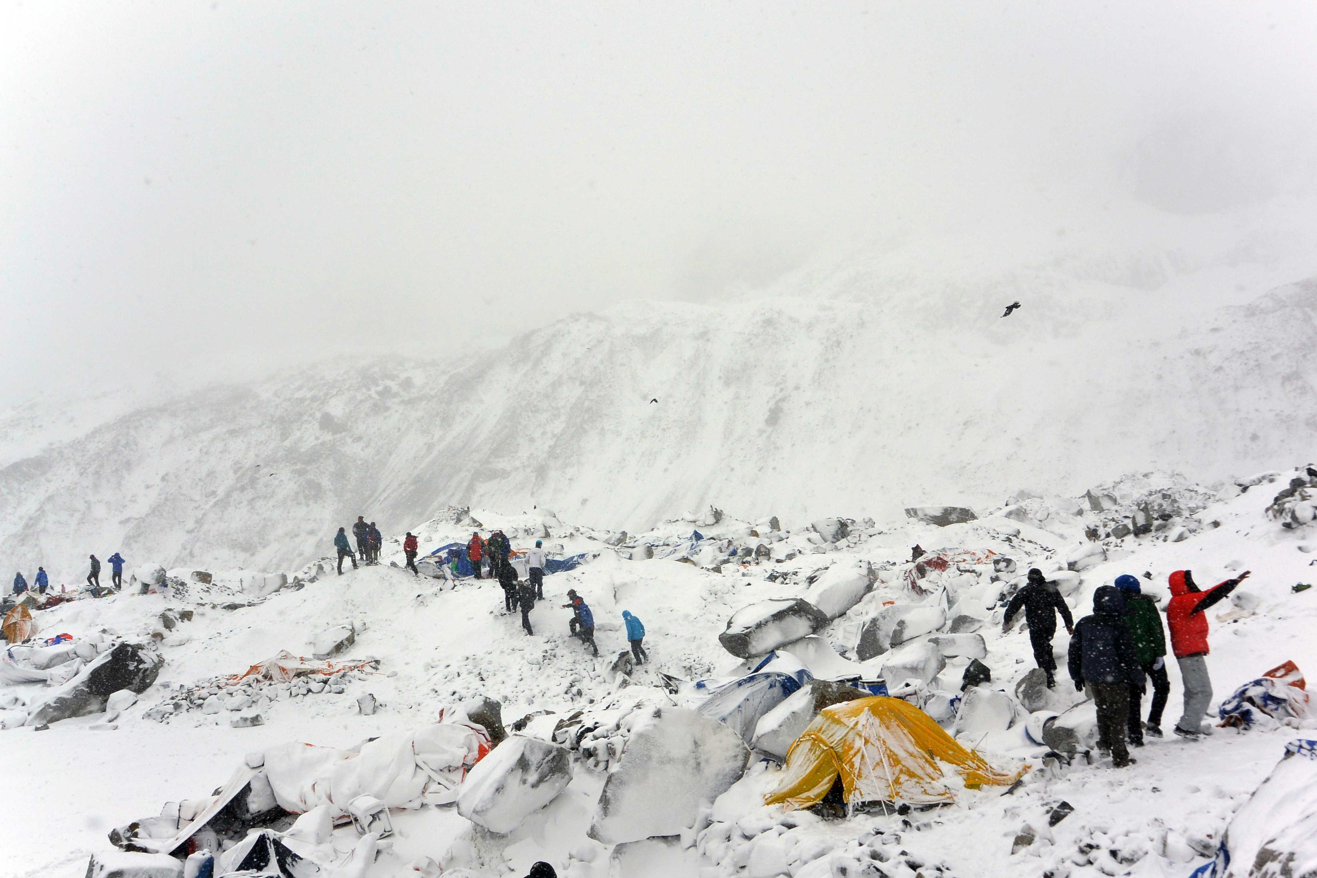
During mountaineering expeditions, a lot of effort has gone into removing the materials and gear that climbers left behind on Everest’s slopes, including hundreds of oxygen cylinders. Moreover, tons of waste, such as abandoned tents, tin cans, crampons, and human debris left behind by previous climbers, have been cleared from the mountain. However, the bodies of more than 300 climbers who lost their lives on Everest, particularly at higher altitudes, remain in situ, often deemed unreachable or too difficult to remove due to their weight.
Several notable initiatives have been launched to clean up Everest and raise awareness about environmental issues, particularly regarding climate change in the region. For instance, Eco Everest Expeditions and the initiative honoring Sir Edmund Hillary, the first person to summit Everest, are commendable efforts in this regard. These expeditions not only emphasize ecological preservation but also call attention to the obvious effects of climate change, such as the melting of the Khumbu Icefall that local climbers have observed.
The Challenges of Climbing Mount Everest

Climbing Mount Everest and reaching its summit remains an exceptionally demanding feat, despite the progress made in equipment, transportation, communication, and weather forecasting. The remote location of the mountain, especially on the Nepalese side where there are no roads, presents logistical challenges. In the past, both humans and animals had to travel great distances to transport all supplies. Although the construction of airstrips and helicopter services in the Khumbu Valley has facilitated access to the Everest region, reaching higher altitudes can still only be accomplished through traditional trails. Additionally, there is now a route from Tibet leading to Everest Base Camp on the northern side.
The optimal climbing periods on Everest are limited to two relatively short windows. The primary climbing season occurs in April and May, just before the onset of the monsoon. During the monsoon, the snow becomes softer, increasing the risk of avalanches. A secondary climbing opportunity arises for a few weeks in September, towards the end of the monsoon season, when weather conditions may be more favorable. However, from October to March, winter storms persist in the region, making climbing virtually impossible.
The high altitudes of Everest have a profound impact on the human body. The region above approximately 25,000 feet (7,600 metres) in the Himalayas is known as the “death zone” due to the severely reduced oxygen levels. At this altitude, the body attempts to compensate by breathing rapidly and increasing the heart rate. Digestion becomes challenging, leading to a decrease in appetite. Sleep is elusive, and cognitive function can become impaired, with thoughts becoming foggy. These symptoms, caused by oxygen deprivation (hypoxia), make ascending to Everest’s summit extremely difficult. The use of supplemental oxygen from bottled masks can help alleviate the effects of hypoxia, but climbers may become dependent on it, and using it at high altitudes can lead to severe problems, including altitude sickness.
Several other medical conditions can affect Everest climbers and those ascending to high altitudes, including High Altitude Cerebral Edema (HACE) and High Altitude Pulmonary Edema (HAPE). HACE occurs when the brain swells due to increased blood flow in response to oxygen deficiency, and it can lead to coma and death. HAPE, on the other hand, happens when excess blood is sent to the lungs, causing leakage into the air sacs, often resulting in death from drowning. The most effective treatment for these conditions is to descend to lower altitudes. Additionally, the use of a drug called dexamethasone has been found to aid affected climbers in regaining mobility when administered during periods of inactivity, making it a valuable emergency first aid treatment.
Routes and Techniques Used to Climb Everest
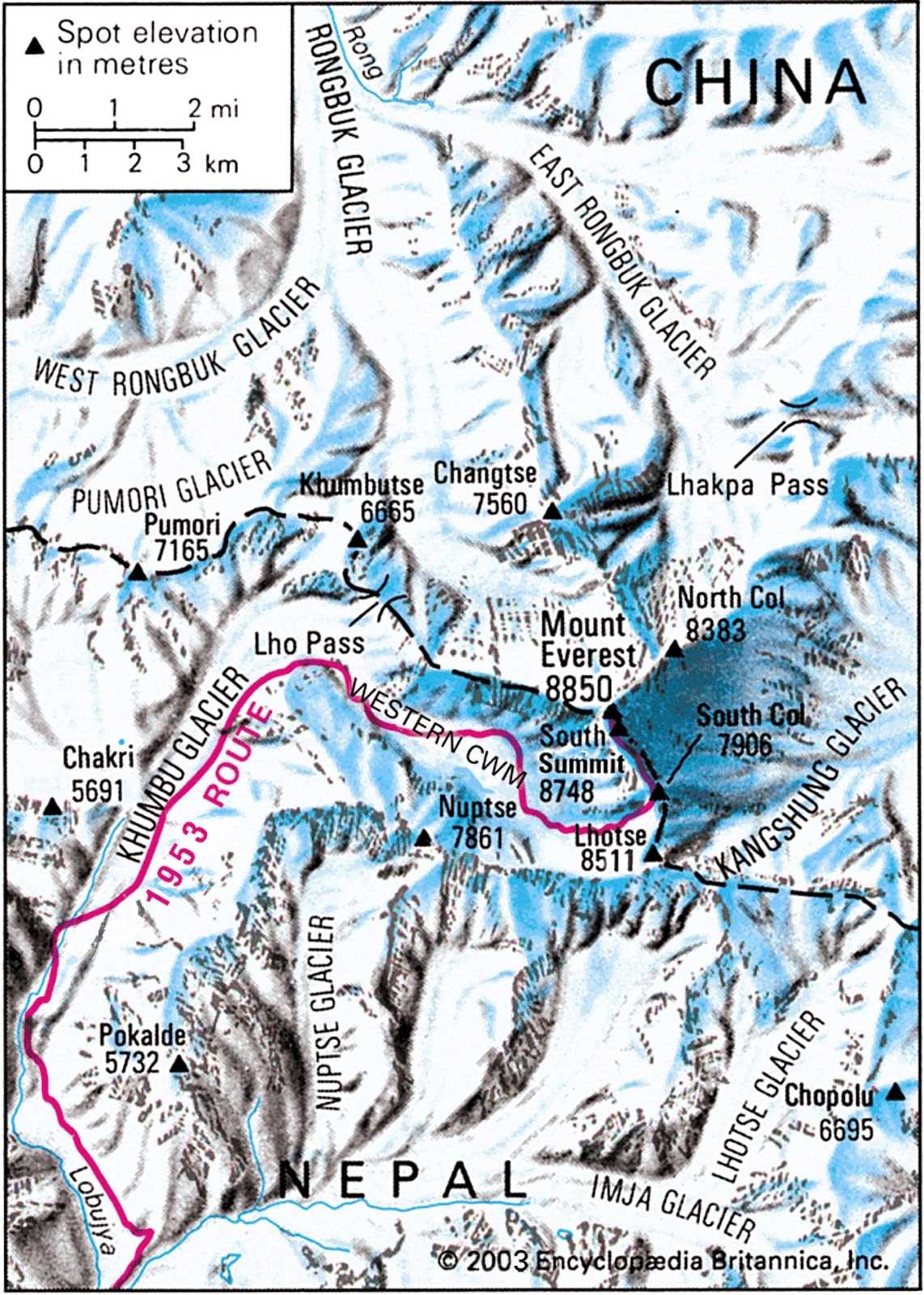
Climbers attempting to reach the summit of Everest frequently choose the Khumbu Icefall and the South Col route as their paths. This route gained historical significance when New Zealander Edmund Hillary and Sherpa Tenzing Norgay successfully ascended it during the 1953 British expedition, becoming the first humans to reach the summit of Everest. On the other hand, the northern route, which seven British expeditions attempted in the 1920s and 1930s, failed and is not as well-known. However, there have also been successful climbs on this route, with a Chinese team making the first successful ascent in 1960. Even though ascents of Everest’s East Face, the mountain’s largest face, are uncommon, an American team did so in 1983.
In the early days of Everest climbing, many mountaineers had military backgrounds, leading to the adoption of the “siege” climbing technique. This method involves establishing consecutive camps as climbers progress up the mountain. For example, on the frequently used South Col route, the main base camp on the Khumbu Glacier is located at approximately 17,600 feet (5,400 metres) above sea level. Climbers ascend to set up camps progressively higher, but when night falls, they descend to sleep one camp below the last established one (referred to as “Climb high, sleep low”).
This practice aids in acclimatizing to higher altitudes. Along the route, camps are set up at intervals of around 1,500 feet (450 metres), named Camp I, Camp II, and so on, with the last camp located 3,000 feet (900 metres) below the Everest summit. The “summit team,” a small group, then proceeds to reach the summit. This approach was traditionally used in British-organized Everest expeditions and is still employed by many commercial expeditions today, with only fully paid clients given a chance to reach the summit. The logistical support provided by the Sherpas is crucial in siege climbing.
As mountaineering evolved in the early 20th century, critics began to view large-scale expeditions with guided climbers using supplemental oxygen and relying heavily on Sherpa assistance as lacking in “true sportsmanship.” British mountaineer Eric Shipton highlighted how these large expeditions overshadowed the aesthetic aspects of mountaineering, with the sole focus being on reaching the summit.
In the 1970s, the best climbers sought a more traditional “Alpine” climbing style for conquering the world’s highest peaks, including Everest. In this style, a small team of three or four climbers ascends and descends the mountain as quickly as possible, carrying all necessary equipment and provisions in a lightweight manner. This approach does not require setting up extensive fixed ropes or carrying heavy oxygen canisters. Speed becomes essential in Alpine climbing. However, this style necessitates the team acclimatizing for at least four weeks at the base camp and its vicinity before attempting the climb.
The History of Everest Mountain Climbing and Edmund Hillary

The earliest recorded attempts to climb Mount Everest can be traced back to 1890, when British military members first envisioned the idea. British soldiers initiated their initial climbing attempts in the early 1900s, and numerous endeavors were made until 1953. Notably, Edmund Hillary, who possessed a military background and served in World War II, achieved the distinction of becoming the first person to reach the summit of Everest in 1953. This historic expedition was supported by esteemed British institutions, namely the Royal Geographical Society and the Alpine Club. After undergoing a three-week training period in the neighboring mountains, the climbing team commenced their ascent from the Khumbu Icefall, meticulously tracing their route.
As the team progressed towards the summit of Mount Everest, they encountered several formidable obstacles. The first significant challenge was a relatively flat rock ridge, spanning about 400 feet (120 metres) in length and flanked on both sides by sheer cliffs covered with ice. Despite the difficulty, the team successfully overcame this obstacle. However, another momentous challenge awaited them between the South Summit and the main Everest summit. This section, now known as the Hillary Step, consisted of a steep rock and ice face. Although it was only approximately 17 meters high, its extreme incline meant that a single mistake could prove fatal.
Unlike modern climbers who benefit from fixed ropes to navigate through this treacherous section, Hillary and Tenzing had only basic ice climbing equipment at their disposal. Displaying astonishing skill and unwavering courage, Hillary and Tenzing meticulously ascended this perilous segment, inch by inch, pressing their backs to the rock and wedging their feet into cracks between ice and rock. Eventually, the indomitable duo triumphantly reached the summit of Everest at approximately 11:30 a.m. After capturing photographs and savoring some sweet treats, they spent approximately 15 minutes at the top of the world before beginning their descent. This historic achievement etched their names into the annals of mountaineering history and left an enduring legacy as the first humans to conquer the formidable peak of Mount Everest.